
Best Apps for Architects
For architects, much of their work happens outside the office at project sites and in meetings with clients and contractors. Being on the road so often, architects lose a lot of time on tasks like transferring and organizing photos, printing and annotating floor plans, measuring, tracking time and expenses, and more.
Luckily, your smartphone or tablet with the right apps on it can help you streamline all these processes.
Today thousands of architects are already using their mobile devices to take the pain out of site inspections, field reports, floor plan annotations, time and expenses, measurements, viewing and editing models on-site, and much more.
And so should you. Harness the power of today’s technology by embracing the apps most useful to architects.
Our Pick of The Top Apps for Architects
We tested lots of apps for architects, analyzed the reviews, and asked our architect community which apps they like best.
Here’s our updated list of the most useful mobile applications for architects.
Best Apps for CAD Drawings & 3D Models
- AutoCAD
- BIMx
- ViewER
- ARki
Best Apps for Site Inspections
- ArchiSnapper
- CamToPlan
- RoomScan LiDAR
- Polycam
- DroneDeploy
- Bluebeam
Best Apps for Sketching
- Morpholio Trace Pro
- Procreate
- Concepts
- Autodesk FormIt
Best Toolbox Apps
- Sun Locator
- Construction Master Pro App
- Other Toolbox Apps
Apps For Productivity and Collaboration
- Access documents and files
- Manage to-do lists
- Plan travel
- Track time on projects
Best Apps for CAD Drawings and 3D Models
AutoCAD Mobile App

AutoCAD’s mobile app lets you edit, create and view DWG files from your mobile device in the field. This app puts an end to printing and bringing drawings to the site. Draft, edit, mark up and measure plans at the job site or on the go. Collaborate with colleagues and make changes in real-time, reducing communication delays and trips to and from the job site. While heavy-duty CAD work is still best left to your workstation, our architect community rated this as their #1 app for many architects.
Features:
- View and edit DWG files from Autodesk’s cloud, or external cloud storage like Google Drive, Dropbox, and OneDrive.
- Mark up drawings and add comments.
- Use the Leica DISTO laser measurement device to update line lengths in real-time directly in the app (Android only).
- Draw and edit shapes using object snap and keypad input.
- Select, move, rotate, and scale objects. View coordinates and properties.
BIMx

Are you an Archicad user? Bridge the gap between the design studio, the client’s office, and the construction site with BIMx, Graphisoft’s presentation, and coordination app. BIMx features the ‘BIM Hyper-model’ – a game-like navigation environment that helps even non-professionals easily explore the building model and understand project deliverables. Real-time model cut-throughs, in-context measuring, and project markups in the model context make BIMx a great BIM companion.
Features:
- Gives full access to BIM content like 3D models, construction drawings, schedules, elements, or space information.
- All-round 3D cutaways with animated transactions.
- Hyper-model technology for integrated 2D and 3D building project navigation.
- All the relevant model data is at your fingertips for easy access and sharing.

ViewER from AMC Bridge, Inc. helps architects quickly view 3D models from popular file types, and quickly grab models from storage locations, including cloud file software like Dropbox™. It even lets you superimpose CAD model renders over real-time video from your device’s camera to combine digital models with real objects in a single app. While ViewER is only available for Android devices, iOS users can find similar features in SketchUp Viewer.
Features:
- View 3D models in openNURBS (3DM), Wavefront (OBJ), 3D Systems (STL), Stanford Triangle Format (PLY), and Autodesk Inc. (3DS, DXF, DWF) formats.
- Mix CAD models and real footage in AR mode.
- Find and open models on local storage or shared storage like Dropbox.
- Cache models to improve load times.
- Capture images on screen and share them with colleagues.
ARki

Best for: Visualization of 3D projects in Augmented Reality
Works on: iOS
Price: Free (1 plan), $19/mo – $220/yr (PRO)
Arki helps architects visualize and experience 3D projects in Augmented Reality. You can use this award-winning app for interactive presentations by importing multiple models and creating dynamic layers and toggles to dive into the different aspects of your design. Or, use the “full scale” option to wander around in your 3D models on-site in real-time.
Best Apps for Site Inspections
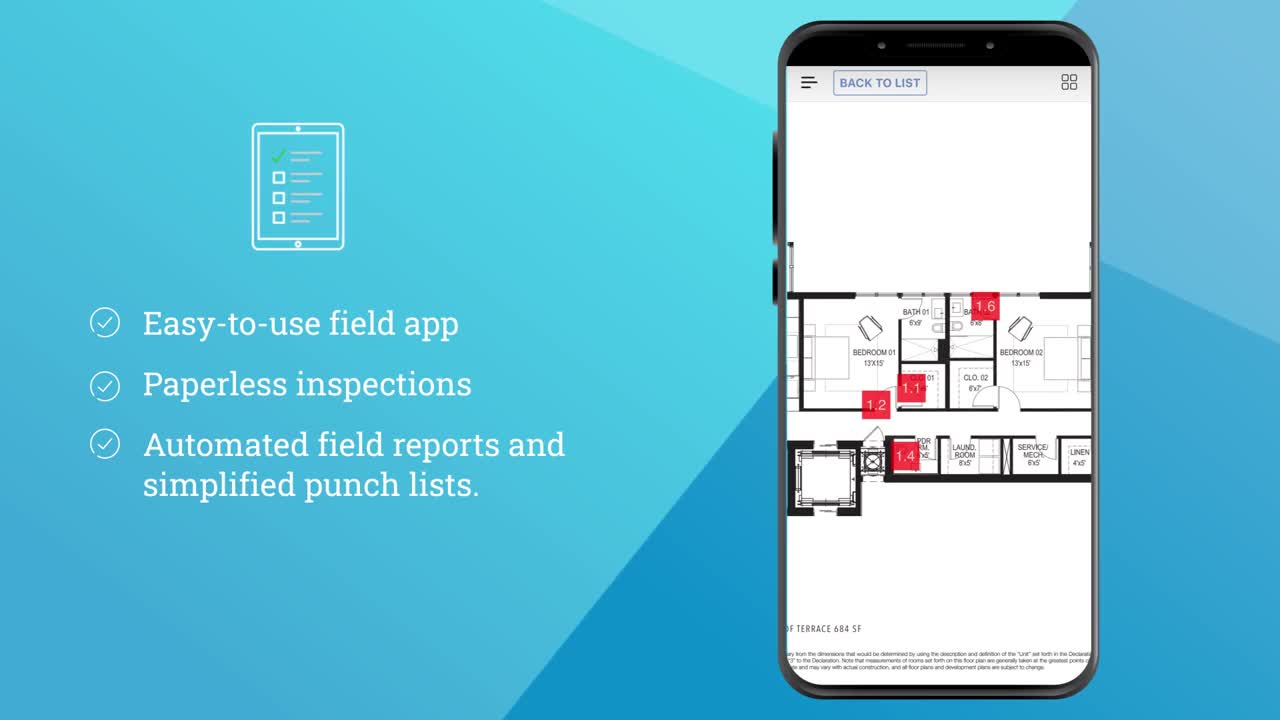
Archisnapper

Best for: Field reports, inspection reports, and punch lists
Works on: Web, iOS, and Android
Price: Free trial, and $25/month per user afterward
Drafting field reports or punch lists from site visits can be very time-consuming and inefficient. ArchiSnapper is the #1 field report app for architects that helps you document items with text, photos, assignees, and floor plan annotations while on-site using your smartphone or tablet. When you’re back at the office, your field report or punch list is available for further editing and sharing. No more struggling with transferring photos or Word to draft field reports.
Noted by both ArchDaily and Architizer as an essential app for architects, ArchiSnapper is already helping 10,000+ architects save time on field reports and punch lists.
Features
- Snap a photo and write text to record any observations or issues.
- Sketch and annotate your photos to communicate more clearly.
- Easily pinpoint observations on your plans helping everyone get crystal clear.
- Generate professional, clean, and branded PDF reports in seconds and send them out to the project team.
- Use voice-to-text to save even more time.
- Collaborate on with assignees on pending items.
- Use checklists for punch lists, daily reports, quality, or safety.
- Integrate with Sharepoint, Deltek Ajera, Deltek Vantagepoint, Dropbox, Google Drive, File Server, Outlook, and more.

Try Deltek ArchiSnapper for Free
Join 10,000+ architects, engineers and contractors who use Deltek ArchiSnapper for fast field reports and efficient punch lists.
CamToPlan

Measuring with CamToPlan is easier than with a laser meter or any other measuring tool. You draw your measurement lines in 3D directly on the video of your phone or tablet, and in just seconds, CamToPlan can create measurements of areas and floor plans. You can export the full 3D model in many formats. This app is ideal for quick estimations and visualizing rooms, floors, furniture, baseboards, and walls.
Features:
- Create floor plans with your mobile device’s camera.
- The app measures distance horizontally and vertically.
- Measure wall dimensions, floors, doors, and windows, an entire house within a few seconds.
- Export your data in PNG or DXF.
New: CamToPlan 3D Scanner
Tasmanic, the creator of CamToPlan, just released a second CamToPlan app named “CamToPlan 3D Scanner“. This app allows scanning a place in 3D in order to build a 3D model:
- You just scan your surroundings with your device camera.
- The 3D scanner only needs a few seconds to digitalize a room or a few minutes to model a large flat or a house.
- Once the scanning is done, you simply add measuring points to measure any distance, length, surface, or area.
- You can export the full 3D model in many formats, including gif, dae and obj.
RoomScan LiDAR

Best for: Creating professional floor plans with your mobile device’s camera
Works on: iOS – Requires iOS 14.0 or later
Price: Free with in-app purchase of $12.5/month for a subscription
RoomScan LiDAR’s developers, Locometric, have a decade of experience creating apps that make the most of iPhone & iPad sensors – and it shows. The RoomScan LiDAR app is as easy to use as tapping each wall and swiping for doors and openings. LiDAR does the rest, enabling you to create an accurate 2D and even 3D model in minutes.
Features:
- Quick, accurate floor plans in any building, furnished or unfurnished. RoomScan LiDAR even scans curved walls.
- Annotate your plans with Apple Pencil and you have plans, annotations, measurements, dictated notes, and photos all in one place.
- RoomScan LiDAR combines machine learning with LiDAR scanning to automatically recognize, measure, and place doors, windows, and symbols on your floor plan simply and accurately.
Polycam – LiDAR 3D Scanner

Best for: 3D scanning
Works on: iOS (iPhone 12 Pro, iPhone 12 Pro Max, or 2020 iPad Pro)
Price: Free with in-app purchase at $6.99/month or $54.99/year.
Another LiDAR-based app that you should definitely give a try is Polycam, a 3D scanning app released in 2020. Just like RoomScan, Polycam uses the LiDAR sensor to enable you to quickly create color 3D scans of spaces. All you need to do is scan the space with your iPad or iPhone. The app generates an accurate 3D scan in a matter of seconds. You can export your 3D scan in many different formats and import it into your CAD program. Last year Polycam released “Photo Mode” which allows you to capture objects in high detail through photogrammetry. In addition to LiDAR Mode, Photo Mode expands the app’s use cases for architects by allowing you to create a library of 3D assets.
Features:
- Use the LiDAR sensor on Pro Apple devices to enable you to quickly create color 3D scans of objects and spaces.
- Single room captures take only seconds to process, and all computation happens securely on your device, no internet connection is required.
- There is no limit to the number of scans you can make or process, which is useful if you want a 3D model of a house or building with multiple spaces.
- Polycam 3D captures are also dimensionally accurate, enabling you to easily measure the distance between any two points.
DroneDeploy

Using photogrammetry, images taken with cameras on drones can be stitched together to create a full-color digital model of the site at a resolution equal to or better than traditional surveying techniques. DroneDeploy makes it easy to pilot drones and convert sites and structures into detailed models.
For inspecting rooftops, or assessing the viability of sites from the sky, DroneDeploy is the ideal accompaniment for architects and landscape architects looking to make the most of drones. For especially large and complex sites, it can turn a job that would take weeks into a single-day operation. It’s a lot easier to fly a drone over a miles-long mining site that spans mountains and ravines than it is to send in a team of surveyors.
Features:
- Capture job site data in real-time with Live Map
- Create a 360 virtual tour of your site to assist in planning and coordination
- Track and communicate progress at any stage
- Measure elevation, distance, volumes, surface area, and roof geometry.
Bluebeam Revu PDF Editor

Best for: Viewing and editing PDFs on the move
Works on: iOS
Price: $349 per seat for the standard package
As we continue to move toward a paperless workflow, architects need a solid PDF program for their tablets. There are plenty of ways to view and edit PDFs on your mobile device, but Bluebeam Revu offers easy PDF editing designed with architects in mind. With Bluebeam, you can quickly markup PDFs with industry-standard symbols and verify measurements, all from your iPhone or iPad.
Features:
- Add comments, images, symbols, multimedia, and more with customizable markup tools.
- Embed multiple photos and videos into markups using the iPad camera, as well as image files from the Document Manager or your iPad’s Photo Library.
- Access Studio Projects created in Revu on Windows and check out and edit Project PDFs, regardless of Internet access.
- Start Studio Sessions or join existing ones to collaborate with colleagues in real-time.
Best Apps for Sketching
Morpholio Trace Pro

Best for: Unique drawing tool that allows you to easily develop ideas in layers, and communicate via drawing markup.
Works on: iOS
Price: Free, with a Pro subscription at $19,99/year.
Created by architects, for architects, Morpholio Trace allows you to instantly draw to scale on top of PDF drawing sets, maps, 3D models, images, or background grids. Unlike other sketching apps, Trace comes with scale tools, so you can use any two points to set a scale in imperial or metric units. This app pushes the boundaries of AR technology, providing you a truly cutting-edge sketching experience. Trace combines the beauty and speed of sketching with the intelligence and precision of CAD This app gets great press and recognition in the architecture world and has been awarded by Apple as a top sketch and drawing app. Architects love this high-tech version of tracing paper.
Features:- Create designs with pens, brushes, scale tools, stencils, and moveable layers.
- Drag in a 3D model and auto-set perspective grids.
- Mark up drawing sets, 3D models, photos, or contact sheets.
- Use the Augmented Reality to jump into and walk around your drawings with others.
- Calculate areas while you sketch using SmartFill.
- Instant scale: use any two points to set a scale in imperial or metric units.
Procreate

Best for: Generating high-caliber artwork at a blistering pace using a robust layering system, and stunning filters.
Works on: iOS – iPad Pro with Apple Pencil
Price: $9.99 (one-time fee)
With Procreate, you get everything you need to create impressive sketches, illustrations, and animations. Hundreds of handmade brushes help you draw accurately and it’s great for working with layers: once you have the beginning of an idea you want to grow, just create a new layer of white, turn down the opacity, add a new drawing layer on top of that, and begin sketching again.
Procreate’s powerful and intuitive interface always puts your art in focus. It actually feels like you’re drawing with a real pencil. The 30k+ ratings with 4.5 as average show just how much love this app gets from its millions of users. While not strictly designed for architectural purposes, Procreate is one of the most popular apps used by architects for sketching and designing.
Features:
- Quick shape feature for perfect shapes.
- Select-and-fill technique to add colour to an area defined by the selection tool.
- Layer your art for precise control over details and composition.
- Import a reference image that will remain in view while drawing.
- New in 2022: Page Assist, to enhance the ideation experience by providing a streamlined sketchbook-like workflow with super-fast layer navigation, and directly supporting PDF import/export.
Concepts

Best for: Infinite, flexible sketching and design
Works on: iOS, Android, and Windows 10
Price: Free, one-time purchase + subscription options
Concepts is a vector-based sketching app used by architects around the world to design homes, communities, and urban landscapes. Flexible, accurate, and extremely responsive, it offers a faster way for creatives to design naturally. One of the features that helps Concepts stand out from other similar applications is its digital sketching paper, which provides an almost natural paper-like feel. The app has been around for many years and has won Best of, Creative and Design awards with Apple, Google, and Samsung for its infinite drawing experience and customizable UI.
Features:
- Flexible: Pick up anything you’ve ever drawn with a tap+hold, and copy it, measure it, change the tool or line weight or colors, or just throw it away. It’s the beauty of traditional tools with the power of vectors.
- Draw with realistic pens, markers, brushes, and CAD-like tools
- Use unlimited imports and layers for tracing.
- Design with real-world scale, measurement, and grids.
- Import plans, PDFs, and images to scale and apply measurements using Concepts’ precision tools, shape guides, and grids.
Autodesk FormIt

Best for: AEC 3D sketching and environment analysis for conceptual and computational design workflows
Works on: Web, iOS, Windows
Price: Free or Paid (FormIt PRO). Note: FormIt Pro is available only as part of the Autodesk AEC Collection, which also includes Revit, Autocad, and more.
FormIt aims to bridge the gap between pencils and pixels, giving architects the ability to sketch out their ideas in three dimensions right at the beginning of the process by offering sketching and 3D modeling capabilities. You can use the app to create models on your phone or tablet, and use real-world site information, solar analysis, and energy analysis during the early design stage of a project. It all adds up to help you make informed decisions earlier in the design process.
While SketchUp has been dominating this space, Autodesk FormIt is a worthy contender, offering intuitive 3D sketching, and conceptual design that helps drive robust BIM. What makes FormIt different from SketchUp is integration. From the outset, FormIt supports a BIM workflow, with the ability to import models and associated data seamlessly to Revit for advanced development. Given that Revit is used by an overwhelming majority of architects to create construction-ready drawings in collaboration with engineers, this is a crucial advantage.
Features:
- Create models on your tablet with 3D sketching tools.
- FormIt supports iteration with Revit to connect your design concepts to BIM without remodeling.
- Use real-world site information to help create forms in context and support early design decisions with real building data.
- Insight helps you optimize building and glazing performance.
- Visualize the solar impact of heat gain on the surfaces of your model.
- Explore the effects of the sun using the location-aware shadow study tool.
- Real-time collaboration: design with your team in the same model, in real-time.
Best Toolbox Apps
Sun Locator

Best for: Tracking and analyzing solar path and shade
Works on: Android
Price: Free (Lite version)
You’ll have all kinds of questions while assessing a site. For example, does a neighboring building obstruct the sun and cause shade? How much sunshine will a house get? Will the sun shine through a window at particular times? Sun Locator answers these questions by providing useful data like the solar path, the winter and summer solstice paths, and sunrise and sunset times. Using a highly interactive augmented 3D view, you can instantly determine the amount of sunlight your building will receive.
This app isn’t intended solely for architects, but it makes for a superb companion for the job. Sun Locator is currently Android-exclusive, but iOS users can use an alternative app called Sun Seeker ($9.99)
Features:
- 3D sundial, to visualize the sun’s position and the shadow direction and length over the course of the day and year on an interactive map.
- Augmented reality sun and moonlight simulation, to fast-forward from sunset to sunrise for any time and day of the year through your camera.
- Day and night world map, an interactive visualization of the earth showing daylight and twilight regions.
- The Lite version is free and limited to information for the current day; the Pro version enables you to get information for any day of the year and to adjust the height of the sundial in the map view.
Construction Master Pro

The Construction Master Pro App helps you solve tough architecture-related mathematical problems, like calculating areas or volumes, laying out stairs, figuring out how much drywall to use, and calculating right-angle solutions. This construction calculator app saves you having to carry around a physical calculator and decreases errors on-site or in the office.
Features:
- Dimensional math and conversions.
- A host of right-angle tools, including irregular hip/valley and jack rafters.
- Expanded and arched rake wall.
- Area, volume, and perimeter solutions with length, width, and height keys.
- Sine, cosine, tangent, arcsine, arccosine, and arctangent trigonometric functions, and a selection of built-in solutions for quick and easy completion of layouts, plans, bids, and estimates.
Other Toolbox apps

Compass: the compass app comes pre-installed on every new iPhone, and it’s helpful for orientation. If you’re an Android user, get Compass.

Level: various apps help you measure the level of an object or surface. If you’re an iOS user, use this feature in the Measure app (see below); if you’re an Android user, try Bubble level.

Measure: iOS augmented reality app developed by Apple for the iPhone and iPad. You can quickly gauge the size of objects, and automatically detect the dimensions of rectangular objects.


Planimeter: This GPS tool (iOS, $7.99) uses a satellite map to make quick site measurements, including perimeters, distances, and angles, in imperial or metric units. The app is easy to use; just drop pins around the area you want to measure on the map. For Android, try Planimeter.

Scan: Did you know your phone or tablet is a scanner as well? iOS users can scan and sign documents with the Notes app. Android users, try CamScanner.

Scala: An architectural and engineering scale shrunk down into app form, this iOS app combines imperial architectural, metric architectural, and engineering scales in a handy app. You can even create custom variable scales if your drawings aren’t on a known scale. With this app, you’ll always have a scale with you.

Houzz: this free app is perfect when you need inspiration for your design project. With thousands and millions of photos of exteriors and interiors, this app allows you to save images, and visualize your finished project.
Best Apps for Productivity and Collaboration While on the Go
Don’t forget to complement the typical apps for architects mentioned above, with more traditional business apps to maximize your overall productivity while you are on the go.
Access all your documents and files wherever you are
- One Drive
- Dropbox
- Google Drive
With cloud tools like these, you get access to all your documents and files wherever you are and share them seamlessly with anybody. But you can also easily switch between your desktop or laptop in the office and your mobile device on the go. No more struggling with getting access to the right documents and information while you are meeting a client or creating a punch list. If you’re already using Office 365, I’d recommend going for OneDrive as it integrates well. Moving to a cloud-based system should be the #1 priority for every architect who hasn’t done so already.
Manage your to do lists and collaborate with others
- Microsoft ToDo
- Google Tasks
- Basecamp
- Trello
Having a To-Do list is essential. With so many things going on, like client information, requests, incoming phone calls, or emails, you don’t want to keep all things that require action in your memory. You need a system where you can record and manage the things that will require your attention, later, when you’re done with your current task. This frees up your mental RAM and gives you the clarity and focus to be productive and have no stress. Some architects have a To-Do list per project.
Plan your travel and avoid traffic
- Waze
- Google Maps
Waze is a free navigation app that helps you get from A to B faster. It uses live user feedback to find better routes. And if traffic is bad, Waze will find a new route to cut down on travel time. Waze (or Google Maps, which is very similar) is a must-have for every architect that spends time on the road.
Track time spent on projects
- Harvest
- Toggl
- Timecamp
- Hubstaff
With these apps, you can log the time spent on a project whenever and wherever you are. No need to use separate notes or excel when you get back at the office. Just tap start and stop the timer on your phone, and at the end of the month, you’ll be able to report on and invoice the time spent per project.
Archisnapper: The #1 App for Field Reports

Try Deltek ArchiSnapper for Free
Join 10,000+ architects, engineers and contractors who use Deltek ArchiSnapper for fast field reports and efficient punch lists.